
Seigonie Mohammed
Trinidad and Tobago may be experiencing a hot spell, but that will not stop parts of the country from facing a risk of heavy rainfall and flooding this afternoon.
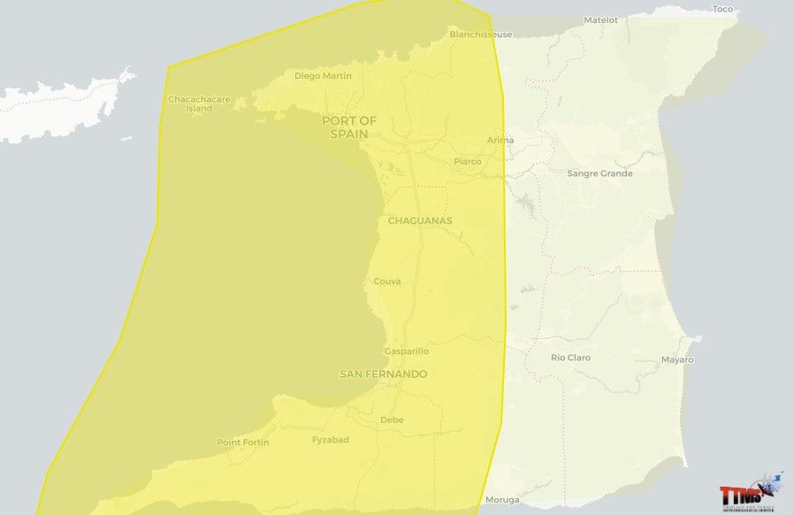
The Trinidad and Tobago Meteorological Service (TTMS) has placed the western half of Trinidad under a Yellow-Level Adverse Weather Alert from 1 pm to 5 pm today, October 5, noting that heavy showers and thunderstorms could produce street or flash flooding, landslips and gusty winds.
The alert comes while the islands remain under a Hot Spell Alert, creating what may appear to be contrasting weather conditions; unusually hot conditions alongside the possibility of intense afternoon rainfall.
But the two can occur at the same time.
According to the Met Service's Adverse Weather bulletin, a combination of local dynamics and a tropical wave is expected to create the potential for impactful weather, particularly across western parts of Trinidad this afternoon.
The TTMS said showers and isolated thunderstorms are also possible across other parts of Trinidad and Tobago, although the western half of Trinidad is where the risk of significant impacts has prompted the Yellow-Level alert.
Heavy rain does not mean the heat is over.
The prospect of rainfall should also not be interpreted as an end to the current hot spell.
Hot spell conditions are determined by temperatures over a period of time, while showers and thunderstorms can develop over much shorter periods when atmospheric conditions become favourable.
That means a location can experience significant heat and still see intense rainfall or thunderstorms later in the day.
For western areas, the immediate concern between 1 pm and 5 pm will be the potential impacts of that rainfall.
The Met Service warned that heavy downpours could result in street or flash flooding, while landslips are possible in susceptible areas. Gusty winds could also occur in and around heavier showers and thunderstorms.
The TTMS has classified the adverse weather alert at Yellow Level, meaning impactful conditions are considered likely and the public should monitor weather conditions.
Residents, particularly those in flood- and landslide-prone communities, are being advised to remain vigilant, while motorists should exercise caution during periods of heavy rainfall.
The changing conditions also underscore an important point during the wet season: a spell of unusually hot weather does not eliminate the possibility of heavy rainfall, thunderstorms or flooding.